
When planning a trip, we tend to have certain expectations about the place we are about to visit, and of course, this was also the case when I booked my hiking trip to Rebun and Rishiri Island. And then, I arrived in Far North Hokkaido and the area completely defied my expectations.
I knew that my Far North Hokkaido itinerary was full of adventure and all kinds of hikes, but the islands’ raw natural beauty caught me off guard. Rebun’s dwarf bamboo-covered hills and mountains that gently slope into the Sea of Japan or Rishiri Island’s picturesque lakes that reflect the towering dormant volcano more than surprised me.
Rishiri and Rebun Island can only be described as Hokkaido’s Northern Island Paradise. As you explore this area of Japan that relatively few international visitors ever venture to, you are rewarded with trails that offer panoramic views of the coastline and the surrounding area, or lush forests that flourish with life.
And if this is not enough to tempt you, this remote paradise will enchant you with around 300 species of alpine plants that can be found at low altitudes. There is no denying that these islands are a paradise for nature lovers, so be sure to include them in your trip to Hokkaido.
I can only say that I am beyond grateful that attending the Adventure Travel World Summit 2023 made me fly to Sapporo and head to Rishiri and Rebun Island. I was instantly drawn in by the country’s natural beauty, and it was the perfect ‘nihon e youkoso‘ (welcome to Japan).

I visited Rebun and Rishiri as a hosted media delegate prior to the Adventure Travel World Summit in Sapporo. Therefore, this article was written in partnership with Visit Hokkaido and the Japan National Tourism Organization. The tour itself was organized by Adventure Hokkaido. As always, all opinions expressed are my own.
Why should you visit Rebun and Rishiri Island?
Situated in the Sea of Japan in Far North Hokkaido, Rebun and Rishiri have a subarctic climate. However, it is this colder weather combined with strong westerly winds that led to the formation of grasslands and that allowed alpine flowers to thrive at sea level.
With their mountains, alpine plants, sea cliffs, wetlands, lakes, and marches, the two islands are the ideal destination for hiking and reconnecting with nature.
The islands are part of Rishiri-Rebun-Sarobetsu National Park, the northernmost national park in Japan. Said national park consists of three parts, with the third one being the Sarobetsu Plain on the mainland south of Wakkanai. These wetlands are one of the three largest marshlands in Japan and are a stopover point for migratory birds.
Despite being close to each other and sharing some features, the islands are also quite different.
About Rebun Island
Rebun’s name derives from the Ainu language and roughly translates to ‘offshore island’. However, it is also known as “Floating Flower Island” thanks to the around 300 species of alpine plants that can be found on the island.

Some of these plants like the Rebun Atsumorisou (Lady’s Slipper Orchid), Rebunus Yukisou, and Rebunkibaisou are endemic to Rebun. You can see them as you wander along the island’s 7 trails in the summer months.
The island is located 60 km west of Wakkanai, and as a passionate scuba diver, the first thing that popped into my mind when I saw the island’s shape was that it is catshark egg case-shaped. The highest peak is the 490 m high Mt. Rebun.
About Rishiri Island
Rishiri is also called the “Floating Dream Island”, and its name translates to ‘high island’. It is a circular island that is located 52 km west of Wakkanai, and there are two towns. Rishiri is located on the western side while Rishirifuji is on the eastern side of the island.
The island is best known for its highest peak Mt. Rishiri and the Rishiri-kombu. While it is a great destination for hiking in summer, you can go backcountry skiing in winter if the weather is good.

Hokkaido’s Far North Itinerary Overview
Did you already read this Japan’s Far North itinerary, and want to book your trip now? If so, this overview is what you are looking for!
Which Tour Company to Choose: Adventure Hokkaido
- Day 1: Getting to Wakkanai
- Day 2: Cape Soya + Getting to Rebun Island
- Day 3: Hiking on Rebun Island — Cape Tour Course, Funadomari Beach, Lake Kushu Course
- Day 4: Hiking on Rebun Island & Ferry to Rishiri — Momoiwa Observatory Course, Himenuma Ponyama Nature Trail
- Day 5: Hiking on Rishiri Island — Mt. Rishiri and Mt. Pon or Cycling
- Day 6: Farewell to Far North Hokkaido — Ferry to Wakkanai & Onwards Journey
This post may contain affiliate links(*), which means I may receive a commission, at no extra cost to you if you make a purchase through a link. Please see the full disclosure for further information.
Far North Hokkaido Itinerary: Rishiri Island & Rebun
About this Rishiri and Rebun Itinerary
Like all of my itineraries, this Far North Hokkaido Itinerary is ideal for adventure and nature lovers. But given the remoteness of Rishiri and Rebun, it is only for those who do not mind longer transits to truly venture off the beaten path and who want something different.

Given that it includes a lot of hikes with increasing elevation gain, it is therefore targeted at travelers who want an active itinerary (with the potential to be vigorous if you choose to summit Mt. Rishiri). Due to this, you should be in good physical condition.
Of course, you can still enjoy the islands if you are not a fan of daily hikes. However, you will miss out on some of the most scenic views of Rebun and Rishiri Island. Nonetheless, you could simply visit the viewpoints and just do shorter hikes on mostly flat terrain.
I visited Rebun and Rishiri Island as a guided group trip organized by Adventure Hokkaido and loved it, but at the time of writing, this Far North Hokkaido itinerary is no longer offered as a guided tour. However, the Adventure Hokkaido‘s Self-Guided Northern Islands Tour closely mirrors this itinerary.
And while you could plan a trip to Rishiri and Rebun on your own, I encourage you to book your adventure in Hokkaido’s Far North with them, as their support is invaluable. Especially, as not all information is available in English and because not all accommodations on the islands can be found on popular hotel booking websites. You can read more about why I would book the trip with them at the end of this itinerary.
Day 1: Getting to Wakkanai
Rebun and Rishiri Island are off the beaten path, and if you want to travel sustainably, your itinerary will reflect this in the form of a transit day, as it takes a while to get there. In fact, I did not make it to Wakkanai until 6:30 PM despite landing in Sapporo early in the morning. And while this might be off-putting, I promise that the chance to explore Hokkaido’s far north more than makes up for the long journey.
Getting from Sapporo to Wakkanai by Train
If you are flying into Sapporo or are already there, the most convenient way of getting there is to take the direct train from Sapporo to Wakkanai. The JR Limited Express ‘Soya’ departs once a day at 7:30 AM and arrives in Wakkanai at 12:42 PM, so the travel time is 5:30 h.
When you look it up on Navitime, the starting point is ‘Sapporo (Hakodate Line)’. The train ride with a non-reserved seat costs ¥10.560, while a reserved seat ticket costs ¥11.090. I highly encourage you to book a reserved seat if you are traveling with a lot of luggage.
While this route is included in the JR Pass, it is only worth it to use it if you travel to Wakkanai on the day it expires. After all, you will not be using it for the rest of this trip to Rebun and Rishiri Island.
Getting to Wakkanai by Bus
In case you arrive later in the day and cannot take the early train, you can also take the bus. It is what I ended up doing as I arrived too late to catch the train. The route is served by Soya Bus and Hokuto Kotsu, and there are six buses a day.
The bus ride takes 5:50 hours and there are two short stops along the way. The daily departures are at 7:40 AM, 10:30 AM, 1:00 PM, 3:00 PM, and 5:00 PM, as well as an overnight bus which departs at 11:00 PM and arrives at 6 AM.
You can find more about the bus timetable for the Wakkanai route here (use Google Translate to read it).

In Sapporo, the bus departs at Odori Bus Center close to Sapporo Tower and you have to pay cash. So withdraw a sufficient amount of money before heading there or you will have to do an ATM run like I did. Thankfully, there is a 7/11 ATM just around the corner.
The one-way fare for adults is ¥6.700 and ¥3.350 for children. Meanwhile, a roundtrip costs ¥12.000. If you know for sure which bus you can take, you can save money by reserving a seat online for ¥6.030.
Get there by Plane
You also have the option of flying to Wakkanai or Rishiri, but if you are already in Hokkaido, I highly recommend taking the train or bus as doing so is the sustainable option. There are daily flights from New Chitose (Sapporo) to Wakkanai, as well as flights from Sapporo to Rishiri. The bus ride from the airport to Wakkanai costs ¥700 oneway.
There are also daily flights from Haneda (Tokyo) to Wakkanai, which are a good option if you have to fly to Hokkaido anyway. You could take the train from Tokyo to Sapporo and then take the bus or train to Wakkanai, but given that doing so takes over 8 hours and includes switching the train in Hakodate, it is admittedly not the best option if you are short on time.
Wakkanai – where to stay
Depending on when you arrive in Wakkanai, you either use the afternoon to explore Wakkanai or spend the evening in your hotel. Do yourself a favor and do not go to bed too early if you just arrived in Japan from Europe so you wake up in the morning and are more adjusted to the time zone. You might not be able to avoid the jetlag, but I promise it will make it more bearable.

There are several hotels in Wakkanai, and the prices vary depending on the season. I wanted the convenience of being right at the bus and train station, so I stayed at The Stay Wakkanai.
While the rooms are very minimalistic, it is very clean and the staff is rather helpful. You can choose between dorms and private rooms with a shared bathroom, and there is a sitting area and a small kitchen.
Day 2: Cape Soya & Ferry to Rebun Island
While you could also spend the morning of day 2 in Hokkaido’s far north exploring Wakkanai, I recommend heading to Cape Soya before taking the ferry to Rebun Island. After all, doing so is a fantastic way to see more of the surrounding area as the bus there follows the coastline.
If you want to do so, you have to take the last daily ferry to Rebun. Upon arrival in Rebun, you can then spend the afternoon or even explore nearby parts of the island or relax in the onsen of your accommodation.
Cape Soya
Located 35 km east of Wakkanai, Cape Soya is Japan’s northernmost freely accessible point and is the main tourist destination of the area around Wakkanai. And while the Cape Soya Monument that commemorates this northernmost location is the most photographed spot, there are many more things to see.
While walking along the pathway to the sides of the monument, you will likely see herons and fish, and on a clear day, you can spot Russia in the distance. Afterward, you should walk up the stairs on the other side of the street to Cape Soya Peace Memorial Park.


Located at the top of a hill, this park features several statues, a lighthouse, a windmill with a nearby flower field, and a watch tower.
If you want to make it on time for the last daily ferry which departs at 2:24 PM (June to September), you have to take the 9:39 AM bus to Cape Soya and return to Wakkanai with the 11:14 AM bus.
Therefore, you only have limited time to spend on site, but I think this side trip is still worth it. It is enough time to walk around the area and see the highlights, even if more time would be ideal.
Useful Information about Cape Soya
Costs: ¥1420 oneway; ¥2560 return (Wakkanai to Soya Misaki)
The bus tickets have to be bought at the bus station in Wakkanai, and you have to pay cash.
How to get there: There are four daily buses between Wakkanai and Cape Soya. The buses to Cape Soya depart at 9:39 AM, 1:20 PM, 4:12 PM, and 7:30 PM. The buses back to Wakkanai depart at 7:21 AM, 8:44 AM, 11:14 AM, and 2:55 PM. The bus ride takes around an hour.
Cape Soya is not the end point of the bus line, so ensure you get off the bus at ‘Soya Misaki’.
Depending on when you arrive in Wakkanai, you can also explore Cape Soya on the first day. Please note, that the last bus from Cape Soya to Wakkanai is at 2:55 PM and that you will have to take a pricy taxi if you miss it.
Ferry to Rebun Island
After returning to Wakkanai, it is time to catch the Heartland Ferry to Rebun from Wakkanai Port. To get there from the train station, you can either walk 1 km or take a taxi.
The ferry ride between Wakkanai and Rebun Island takes 1:55 h, and during the summer months, there are three daily ferries. You can check the schedule here.

There are different areas on the ferry, and I had a 1st class Japanese Room ticket for this route. Unlike the open second class where you sit indoors on tatami mats, the Japanese Room has thick futons and even blankets. They are suitable for up to 10 people.
As is customary in Japan, all areas are quiet, but in my opinion, the Japanese Room is the most comfortable option and the perfect place to rest during the ferry ride.
There are also areas with regular chair sets, so you can opt for those if you prefer it.
As the ferry pulled out of the port, I had a walk around to see the rather outdoor area. There are several rows of seats outside, but you can also walk along short walkways at the side of the ship. I recommend heading there when the ferry is departing Wakkanai or about to arrive in Rebun, as it is the best way to see both places from a different angle.
Costs:
1st class lounge or island view seat* (*only on the Amapola Soya ferry): ¥6.170
1st class Japanese room: ¥5.510
2nd class: ¥3.290
Checked luggage fare for 1 piece (up to 30 kg): ¥670
Useful Information:
- If you have a 1st class ticket, you have to board the ferry at least 20 minutes before departure, while it is 30 to 40 minutes before departure with a 2nd class ticket. You can book the ferry journey up to 2 months in advance.
- You can bring a car on the ferry. A triangular roundtrip for a car that is between 3 and 4 m long costs ¥45.480.
- Get the ‘map for walking on Rebun Island’ from the tourist info upon arrival at the ferry terminal.
Relaxed Evening on Rebun
Upon arriving on Rebun Island, I recommend having a relaxed evening, as the coming days of this Far North Hokkaido itinerary are full of hiking and adventure.
If you catch the last ferry to Rebun Island, you will arrive in the late afternoon, so you will have a limited amount of time before sunset anyway. Therefore, I recommend watching the sunset near your accommodation while looking at the ocean, an onsen visit, and simply enjoying a fantastic meal.
I stayed at a minshuku (Nature Inn Hanashin) and they prepared a wonderful dinner. While everyone else had a traditional meal with fish, they prepared a special vegetarian meal for me.
Hereby, it was crucial to note that they were informed of my dietary restrictions well in advance, and I am more than grateful that Adventure Hokkaido organized meals I could eat for me.

Alternatively, you could also do what I did on the evening of day 3 and spend some time at Meno-hama to watch the sunset.
If you arrive on Rebun earlier in the day, you can also visit the Rebun Town Local Museum to learn more about the island’s history. After all, Rebun has a long history that dates back to the 4000-year-old Jomon culture. Some ruins of this time remain and shell accessories have been found during excavations. 1500 years ago, it was inhabited by people of the Okhotsk culture which specialized in fishing, stone, and bone tools.
As is typical for many places, the Ainu also settled on the island around 400 years ago. While it is known that the people focused on fishing and traded with people in Japan, very little additional knowledge of the local Ainu culture remains.
Day 3: Hiking on Rebun Island
Day 3 of this Far North Hokkaido itinerary has you explore the Northern part of Rebun Island and the island’s capes. It is a day full of coastal views you likely do not expect to see in Northern Japan and potentially also wildlife spotting in the afternoon.
Cape Tour Course
After a good breakfast, your day of hiking starts at Cape Sukuton, the northernmost point of Rebun. Chances are, that you will spend a while at this cape before you start hiking, as there is a trail leading down to a viewing platform that offers a great view. From here, you can see the uninhabited Todo Island. It tends to be windy in this area, so ensure everything is properly attached to you or your backpack.
There is also a café and souvenir shops where you can buy everything from magnets to local sweet treats and even cans of stellar sea lion meat. Have a short look around and buy some trail treats if you want to, before starting the hike.

The Cape Tour Course follows the coastline from Cape Sukoton to Cape Sukai and is also known as the ‘Misaki-Meguri Trail’. This alternative name is more than fitting as it translates to “touring the capes” which is exactly what this hike allows you to do.
As you walk along the trail you are rewarded with breathtaking views of the island’s capes, rolling hills and mountains, and coastal views. Therefore, it is undeniably one of the most scenic trails in Hokkaido’s Far North.
At the beginning of the trail, you walk along the street until you reach a dirt trail. Just before it, I recommend stopping at the Todojima Observation Deck to take in the view, and then the first climb of the hike begins.
As the dirt trail diverges from the road in a curve, you hike up on an inline that is framed by dwarf bamboo. After a while, you reach the Cape Gorota Observation Deck, the highest point of the trail. Be sure to look back as you are gaining elevation, as the coastal view unfolding behind you is more than scenic.


Once at Cape Gorota, you can see the trail on both sides and as you continue hiking along it, you will walk along the ridgeline. As you look around you, you will see some of the alpine plants Rebun is famous for and of course rolling hills that descend into the sea.
After a longer downhill section, the trail runs along Gorota Beach to Teppu village. The next part of the Cape Tour Course was closed due to a rock slide when I visited Rebun, but a detour via roads was available. It is possible to do it on foot, but we were picked up by a van near Teppu and transported to Cape Sukai, the endpoint of the actual trail.
While the detour might be an inconvenience, you should still head to Cape Sukai, as it is one of the most picturesque spots on the island. There is a small bay to the right, and once you reach the Cape, you can see the hilly coastline of Rebun.
As there is no bus stop right at Cape Sukai, you have to walk along the road to the closest bus stop. Thankfully, this road will take you right past the Rebun Lady’s Slipper Reserve.
about this hike
length & duration: 12.4 km (to ‘Hamanaka‘ bus stop) — 5:20 h — 190 m elevation gain
starting point: Cape Sukoton
bus stop at the starting point: ‘Cape Sukoton‘ (¥1240 from Ferry Terminal; 49 minutes)
endpoint: Cape Sukai (but you have to walk to the ‘Hamanaka‘ bus stop)
Funadomari Beach
While you could eat your bento box lunch at Cape Sukai, I recommend doing so at Funadomari Beach. This long beach is best known for its shells with round holes in them. The perpetrators behind these holes are Tsumetagai snails that shrill into the shells to eat the shells’ meat.
The closest bus stop to the beach is the ‘Funadomari Honcho’ bus stop [¥990 (44 minutes)
to the Ferry Terminal].
If you want to see seals, you can walk to the seal watching spot at Cape Kaneda-no-Misaki after visiting the beach. There are no nearby bus stops, and walking the 2.6 km will take approximately 35 minutes. I recommend checking if the sea is calm while you are at Cape Sukoton in the morning, as the likelihood of spotting seals decreases when the sea of rough.

Lake Kushu Course
Lake Kushu is the only lake on Rebun Island and there is a trail around it. It starts at a campsite and in the beginning, you walk along the lake shore.
Eventually, the route turns into a boardwalk through marshland where you will find a bird observation hut. In spring and fall when migratory birds make a stop on the island, this route is a bird watching paradise, so plan to spend some time here.
The final section of this walk is alongside the street and leads you back to the campsite.
When I walked the Lake Kushu Course there were some flowers at the side of the trail, but to my dismay, there were significantly more mosquitos than plants.
Given this and that I did it too early in autumn, it was admittedly my least favorite hike of Rebun and Rishiri Island. However, I would love to do it again once the birds are in the area.
about this hike
length & duration: 4.2 km — 1:40 h
starting point: Kushu Lakeside Campsite — loop hike
nearby bus stop: ‘Byoinmae [Funadomori]’
If you visit the island outside of the bird watching season, I encourage you to consider doing one of these alternative Rebun Island hikes. That is if there is still enough daylight left to complete the hike.
- Mt Rebun Course: 9 km return hike – 4 h (the ‘Nairo’ bus stop is right at the trailhead)
- Rebun Forest Course: 8.2 km – 3 h
- Rebun Falls Course: 4 km return hike – 2:30 h
- Eight Hours Course: 16.5 km – 7 h

On the way back from Lake Kushu to the minshuku we saw locals collect dried kelp, so, of course, we had to stop to learn more about the harvesting and drying of kelp.
While it is known as Rishiri kelp (Rishiri-kombu), it can also be found on Rebun, but the one harvested on Rishiri is significantly more expensive. After harvesting it from the sea, it is laid out to dry in the sun for 2 days before being sorted by size.
Meno-Hama
In the evening I recommend heading to the other side of the island via the Shin-Momaiwa Tunnel as this is the side of the island that is ideal for sunset missions. First head to Meno-Hama where you will find a small café. The staff is really friendly and as typical for Hokkaido, they also offer soft serve.
Get an ice cream and walk northwards for around a minute to get closer to a rock formation that looks like someone sliced a piece off the cliffs. Known as Jizoiwa Rock, it is said to resemble a giant Jizo statue that is holding its hands together in prayer. Please note that you are not allowed to get up close to it, as there is a risk of falling rocks.
The closest bus stop is ‘Motochi’.


The nearby Momodai Nekodai Observatory is another great spot to watch the sunset. Situated close to Momodai ‘Peach Rock’, it is another great viewpoint to see Rebun’s coastline as well as Nekodai ‘Cat Rock’ in the sea. It takes around two minutes to walk up the stairs of the observatory.
Day 4: Hiking on Rebun & Ferry to Rishiri
If you follow this Far North Hokkaido itinerary, day 4 will be split between Rebun and Rishiri Island. In the morning, you will do a final hike on Rebun, before catching the ferry to Rishiri. After dropping off your luggage at the accommodation, you will then do a shorter walk around a pond, before heading out to enjoy a local dinner.
Momoiwa Observatory Course
The actual trailhead of the Momoiwa Observatory Course is near the top of an incline where you will also find a bus stop. In the best case scenario you will therefore be able to start the hike right at the trailhead.
However, you might have to start your hike at the foot of the mountain. Hereby, you can either walk along the paved street or use a gravel path that cuts through a forest.
Started at the trailhead, on incline will lead you to Momoiwa Observatory from where you have a great elevated view of the ‘Peach Rock’ and the sea. In my experience this tends to be the most crowded area as buses stop nearby, but at least in September the rest of the trail was essentially empty.

As you follow the trail you will see many alpine plants from June to August, but there are plenty remaining flowers even in September. Due to this, I consider it the best hike if you want to see alpine flowers late in the season.
Surprisingly, I even managed to spot an ‘usuyuki-so’ (Rebun’s endangered Edelweiss species) despite these flowers blooming in July! While it was no longer in its prime, I was still more than thrilled to see it.

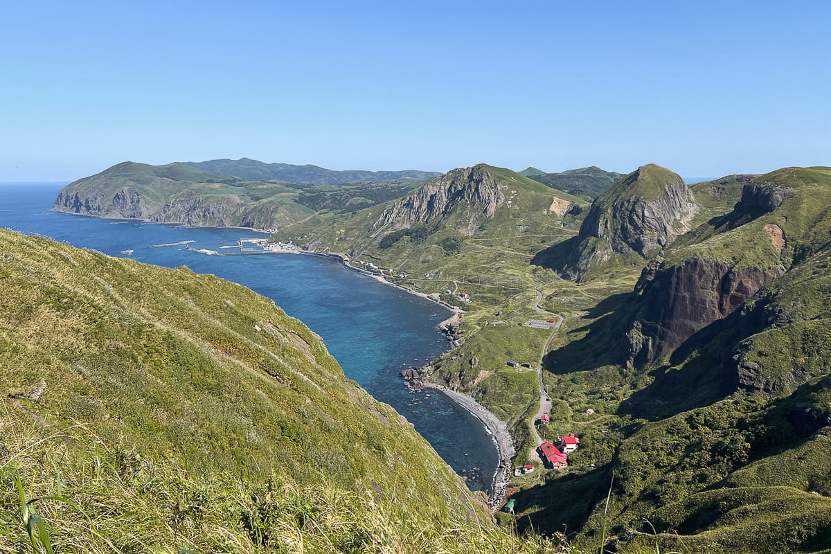

This trail on Rebun has you walking south, so you will be able to see Mt. Rishiri along some sections of the trail. And of courses, you will also have coastal views while you walk along the ridge.
Initially, we were not sure if we would have the time to do the entire hike, but thankfully we were good on time and could walk all the way to Shiretoko via the Motoji Lighthouse.
And let me tell you that I am beyond grateful that we did not turn back after reaching the ‘Winter Jasmine Valley Viewpoint’. After all, the remainder of the trail offers incredibly scenic views.
During the final section leading down from Motoji Lighthouse, you will be walking in the direction of Mt. Rishiri, so enjoy this final view from afar. After all, you will be heading to Rishiri Island once you have completed this final hike on Rebun.
about this hike
length & duration: 7.1 km — 3 h — 250 m elevation gain
starting point: Momoiwa Trailhead
bus stop at the starting point: ‘Momoiwa Trailhead’
endpoint: Shiretoko Village
bus stop near endpoint: ‘Shiretoko‘ (¥320 to the Ferry Terminal)
Ferry to Rishiri Island
From June to September, the most convenient ferry to Rishiri departs at 12:50 PM. Therefore, you should have some time for a quick lunch right at the ferry terminal before the ferry departs.
If you have more than an hour to spare, I recommend checking out the large souvenir shop opposite the ferry terminal. It has a broad selection of souvenirs including a product range featuring the island’s mascot Atsumon. I have to admit that this store made me realize I would be spending a small fortune buying souvenirs in Japan.

The ferry ride from Rebun to Rishiri only takes 40 to 45 minutes. Rishiri Island has two ferry ports so be mindful of where the ferry you are taking is heading.
Costs:
1st class island view seat* or lounge (*only on the Amapola Soya ferry): ¥2.180
1st class Japanese room: ¥1.870
2nd class: ¥1.140
Himenuma Ponyama Nature Trail
Drop off your luggage at your accommodation, before heading to Himenuma Pond. Once three smaller ponds, it was turned into a larger lake by damming the spring water of Mt. Rishiri in 1917. The pond is surrounded by trees which creates a tranquil environment that is the perfect place for a leisure afternoon walk.
Upon arrival, you will instantly see the reflection of Mt. Rishiri on the pond’s surface. Enjoy the view for a while before venturing down the trail to your right. It is an around 1 km long, well-maintained trail that at times consists of boardwalks, and as you look around, you will spot birds and fireflies.
With is relatively flat terrain, it is an easy trail that takes no longer than 20 minutes. Bure sure to check out the ‘Himenuma Shop’ once you have completed the loop, as the owner sells beautiful photos of the local wildlife and area. They also sell coffee, so buy a cup and sit down on the nearby table to enjoy the view some more. We also brought some Japanese treats and let me tell you that it was one of the most scenic snack breaks I had in Japan.


Dinner in an Izakaya
There are many local specialties, and no trip to Rishiri Island and Rebun would be complete without trying at least some of them. And what better way is there than to eat dinner at a local izakaya?
In the evening, we ended up heading to the restaurant of the 1721 Guest House & Bar. It is a local robatayaki restaurant where food is cooked over hot charcoal right at your table, and I have been told that the hokke (Okhotsk atka mackerel) and scallops were fantastic.
Given that they focus on seafood, it is not ideal for vegetarians, but if you do not mind sticking to rice while the rest of your group eats fish, you are in for a wonderful experience.

Other local specialties you should try when you visit Rishiri Island and Rebun are Rishiri kelp, sea urchins, milpis (handmade lactic acid drink), and island ramen is made with seafood broth and toppings like Rishiri-kombu. Stellar sea lion meat is another local specialty.
Day 5: Hiking on Rishiri Island
Unless you have a car, it is highly unlikely that you will be able to replicate my 5th day of this Far North Hokkaido itinerary. After all, it is significantly faster to drive around the island than to cycle to all the places I visited at the end of the day.
Overall, this day is more demanding than the previous days even if you decide not to summit Mt. Rishiri. After all, the hike to the first viewpoint of Mt. Rishiri alone already has more elevation gain alongside steeper inclines than the previous hikes you have done.
And of course, you will be gaining even more elevation if you also hike to the summit of Mt. Pon. If you do not want another day of hiking, you will find an alternative that is based on how I spent the evening below.
Mt. Rishiri and Mt. Pon
Mt. Rishiri, sometimes also called ‘Rishiri-fuji due to its similar appearance to Mount Fuji, is a dormant stratovolcano and is one of Japan’s 100 Great Mountains. It has a height of 1721 m and there are two trails leading to the summit. The Oshidomari trail on the northern side and the Kutsugata trail on the western side.
If you decide to hike to the summit via the Oshidomari trail, you are looking at an elevation gain of 1440 m, and as such the Mt. Rishiri hike to the summit is a 11 h return trip. Therefore, you have to start the hike before 5 AM. Thankfully, many accommodations offer transportation to the trailhead in the morning hours, so you do not have to worry about getting to the trailhead.
We were originally planning to do this hike, but due to the weather, we decided against it. The peak of Mt. Rishiri tends to be windy and clouds roll in quickly, so you will want to do this hike on a clear day.

Instead of going all the way to the summit, we decided to hike up to the first viewpoint and afterward decided to also hike to the summit of Mt. Pon. Given that I hike at a slower pace than others, I decided to stop at station 5. As such, my total hiking distance was 7.3 km.
The trail starts at an elevation of 210 m in a native conifer forest, and after only a few minutes, you will reach Kanro-Sensui Spring, the last water source of the Oshidomari Trail. The water is fresh and clean, so you can fill u your water bottles.
The beginning of the trail is not too steep, but from station 4 onwards, you will face an incline of up to 25%. As you near the summit, the incline will be even steeper. The elevation gain from the camping site to station 5 (613 m) is 403 m. Station 6, the first official viewpoint of Mt. Rishiri, is 141 m further uphill at an altitude of 760 m.
Please keep in mind that there is no shame in stopping or turning back for whatever reason, so you do not have to hike to station 6. Hike at a slow pace and just enjoy being in a peaceful environment full of birds and Ezo chipmunks.
After taking in the view from station 6, you can then either return to the trailhead or simply descend to station 3 (223m) from where you can start the hike to the summit of Mt. Pon-yama (444 m).
Be aware that the trail can be slippery even when the ground is dry. I inadvertently tested how slippery it is twice and let me tell you that I do not recommend the experience.
Mt. Pon is also known as Mt. Daipon and from station 3 it takes around 35 minutes to reach the summit. The additional elevation gain is 163 m. On a clear day, the summit grants you a great view of Mt. Rishiri and the surrounding area. And it is also a great place to say ‘kanpai’ to the mountain with Japanese whiskey.
If you only want to hike to the summit of Mt. Pon, the total distance from the parking area at the campsite is 3.2 km.

Alternative: Cycling around the Island
I visited Hokkaido’s Far North on a guided tour and due to this, we had a van that could transport us to the locations listed below. It was only for this reason that I was able to drive around the island before sunset after hiking to station 5 of Mt. Rishiri and the summit of Mt. Pon.
If you do not have a car and want to see all the places listed, I recommend renting a bike instead of hiking on day 5. Alternatively, you can also have an early start on day 6 of this Far North Hokkaido itinerary, so you can cycle to these places before catching the ferry back to Wakkanai.
Some people on my guided tour ended up renting e-bikes instead of hiking Mt. Rishiri and Mt. Pon and doing so is certainly a good option if you do not want to spend another day hiking. The e-bike rental prices were ¥3.000 for 6 hours and ¥6.000 for a full day at the place I stayed at, so expect similar prices elsewhere.
Rishiri has a 24.9 km long cycling road and you can complete the loop by cycling 35 km along regular roads. There are 16 vending machines as well as public toilets along this loop route. The local tourism board has created an online cycling map, but at this point, it is only available in Japanese. You can find it here.


Be sure to visit the following locations while cycling around the island:
Shiroi Koibito no Oka viewpoint (Numaura Observatory) offers is rather famous view, as it can be found on the logo of Hokkaido’s famous Shiori Koibito biscuits. The name of this viewpoint translates to “White Lover’s Hill” and couples who propose here get a special certificate.
The Otatomari Swamp & Marsh was my favorite stop on the loop around Rishiri Island. It is the largest lake on the island, and if it is not too windy, the flat surface reflects Mt. Rishiri. There are some plants in the water which further enhance the charm of this spot. Thanks to a boardwalk that reaches into the lake, you can walk right to the area where the plant growth stops. There is also a 1.5 km walking trail around the swamp.
Senhoshimisaki Park combines coastal views and Mt. Rishiri as a backdrop. As such, it offers a different scenery than the other viewpoints. In the past, there were seals in this area, but given that they were fed, I am quite happy that this is no longer the case.
The Itsukushima Benten Shrine of the North is located on a small rock outcropping and happens to be a wonderful photo motive as the sun is setting. It is one of 18 Meiji era (1868-1912) shrines on Rebun and Rishiri.
Day 6: Farewell to Hokkaido’s Far North
All trips eventually come to an end, and on day 6 of this Far North Hokkaido itinerary it is time to say goodbye to Rishiri and Rebun and return to the mainland. But of course, you should not leave before enjoying one more traditional Japanese breakfast at your accommodation.
If you collect Eki stamps, you will love the stamp collection at the small souvenir booth of the ferry terminal, so do not push your stamp book too deep into your bag.
If you feel like you have not spent enough time on Rishiri, you could of course also extend your trip. Staying another day means you can spend a full day cycling around Rishiri or go kayaking. Doing so is also the best option if you are set on summiting Mt. Rishiri, as you might have to wait for good weather conditions.
Ferry to Wakkanai
The ferry ride back to Wakkanai departs from Rishiri’s Oshidomari Port and takes 1:40 h. During the hiking season, there are three daily ferries with the latest departure being at 4:40 PM in May and at 5:40 PM from June to September.
On my way back to Wakkanai I took the Amapola Soya ferry and had a 1st class Island View Seat. And while I liked the Japanese Room on the ferry to Rebun, I loved this area as it is located at the front of the boat. The wide windows offered a fantastic view and I was happy to catch a last glimpse of Mt. Rishiri.
Costs:
1st class lounge or island view seat* (*only on the Amapola Soya ferry): ¥5.620
1st class Japanese room: ¥4.960
2nd class: ¥2.990
Checked luggage fare for 1 piece (up to 30 kg): ¥670

Onwards from Wakkanai
Once back in Wakkanai, you can either spend the day exploring the town or head onward to your next destination right away.
If you are heading to Sapporo after returning to Wakkanai, you can take the direct train that departs at 5:44 PM. Doing so means you have to take the first or second ferry of the day, so ensure you do not miss it. Alternatively, you could also take a train to Asahikawa where you have to change trains. There are two daily departures at 6:39 AM and 1:01 PM. In addition, you can take the bus or fly to Sapporo if you are very short on time. And of course, you can also fly straight to Tokyo.
Should you have some time to spare, you should visit the Wakkanai Tourism Office. It is a great place to get some free souvenirs in the form of Eki stamps, and there are also several gotcha machines with things like pins that feature the seal mascot of Wakkanai. I have a magnet collection so I got a pin (intending to turn it into a magnet).

I turned the wheel and luckily got a plastic capsule with the pin I wanted, only to have a lady run our way while shouting “Atari, atari, atari”. We had no clue what was going on, but eventually, we learned that Atari means “win” in this context.
After some waiting, I was eventually handed my prize: a package of one of Wakkanai’s specialties: octopus! The irony that I was the one to win it when I am allergic to seafood is not lost on me, but if you want to win octopus too, you should try your luck.
If you are not sure where to travel next after exploring Rishiri and Rebun, I highly recommend exploring Akan-Mashu National Park in the east of Hokkaido.
Far North Hokkaido Itinerary Map
If you are planning a trip to Rebun Island and Rishiri Island based on this Far North Hokkaido itinerary, this map will help you visualize where the mentioned trails and locations are.
All significant locations listed in this itinerary are marked, on the map and sorted by date. I recommend creating a copy of the map so you can add or remove points of interest for your own adventure in Hokkaido’s Far North.
Please note that Google Maps will not always show you the exact route of the trails, so do not use the suggested walking routes for hiking on Rebun.
Why I’d always book this Hiking Trip with Adventure Hokkaido
Despite having a fair share of experience when it comes to planning adventures all around the world, I would have had a hard time organizing a trip to Rishiri and Rebun, as a lot of information is hard to find or only available in Japanese. And while this itinerary certainly makes it easier for you to plan a trip to these remote islands, there are still a lot of reasons to book this hiking trip with Adventure Hokkaido.
I have to admit that I loved doing this Far North Hokkaido itinerary as a guided hike. Our two guides Tobaji and Zac were fantastic and incredibly helpful while providing a seemingly endless amount of information about what we saw while hiking.
But given that the self-guided trip itinerary closely mirrors my own, and that the Adventure Hokkaido team is never more than a phone call away and will furthermore be just as helpful as our guides, you should book the trip with them if you liked this itinerary.

I got to experience how great their support is while planning the side trip to Cape Soya and while figuring out the best way to get to Wakkanai, and they instantly provided detailed information that made it incredibly easy and stress-free to explore the northernmost point of Japan before meeting up with the rest of my guided tour group and guides.
The Benefits of Adventure Hokkaido Tours
1. They are a locally owned company (with local guides) that knows Hokkaido better than most. Therefore, they recommend places and organize activities most would not know.
2. You do not have to worry about how sustainable your trip is. The Adventure Hokkaido team focuses on sustainability and is passionate about the outdoors and Hokkaido, so they do what they can to ensure your trip to Rebun and Rishiri is as sustainable as possible.
3. They make your trip stress-free. They also book everything for you, so it does not matter if accommodations and activities cannot be found on popular travel booking websites or if things have to be booked via a phone call in Japanese.
4. Support is never more than a call away. I have mentioned it before, but I cannot emphasize it enough as having the support of a knowledgeable team is invaluable when you explore remote areas of Japan and do not speak Japanese. It might only be something as simple as a missed bus and therefore having to call a taxi, or something bigger, but they will help you solve any issues.
5. They take care of things you would struggle to organize. Ahead of venturing to Hokkaido’s far north, I was worried about the food situation. After all many people in Japan do not understand what a vegetarian or vegan diet is. Therefore, having Adventure Hokkaido handle the organization of meals you can eat is incredible.
About their ‘Northern Islands 7 Day Self-Guided Tour’

Unlike my 5 days long guided tour, the Northern Islands Self-guided Tour is 7 days long. Therefore, a day in Wakkanai not unlike the one I included in this Far North Hokkaido itinerary is included, and you also have an additional day on Rishiri.
Thanks to this, you can explore more of what the island has to offer and do both the Mt. Rishiri hike and the 60 km cycling tour or a kayaking tour.
The price for this self-guided tour starts at ¥299.000 per person and depends on which accommodations are available. You have to book the trip at least 90 days in advance, but if you want a larger selection of accommodations to be available, it is best to book the tour earlier.
In addition to trips to Rebun and Rishiri Island, Adventure Hokkaido also offers guided and self-guided tours in other parts of Hokkaido, and I can sincerely say that I would join every single tour they offer. As of 2023, they also plan custom tours for groups of at least 6 people and a duration of at least 5 days
Rebun and Rishiri Travel Tips
If you are planning a trip to Rishiri and Rebun Island, these destination-specific travel tips will be useful:
Bring cash — Not all places and buses accept card payments, so having cash on you is vital.

Send ahead things you do not need — If you have more luggage than you need while exploring Rebun and Rishiri Island, you can use the Yamato luggage forwarding service.
Get a local sim card — It is incredibly useful to be able to look up the bus timetable while hiking on Rebun and Rishiri. An eSim is the most convenient if your phone is unlocked. I got my eSim via Airalo and had reception even while hiking up Mt Rishiri.
Download useful apps — The following apps are useful for a trip to Rebun and Rishiri Island: Google Maps, MapsMe (better for hiking as individual stations are marked), Windy.com (a weather app that is especially useful if you want to summit Mt. Rishiri), Google Translate, JapanTravel (look up public transportation timetables, routes, and prices).
Bring these hiking essentials — If you plan to hike on these islands, you should bring the following items: a waterproof jacket and pants, a fleece jacket, a cap, hiking poles, hiking shoes, a head torch, sunglasses, sunscreen, thermal clothes, gloves, a hiking backpack, a reusable water bottle or water bladder, and a first aid kit. I highly recommend also bringing mosquito repellent.
Learn more about the alpine flowers of Rebun — When it comes to flower identification on Rebun, the Rebun Island Botanical Encyclopedia (search by color) and Rebun Flower Encyclopedia websites are useful. Both are only available in Japanese, but you can google translate them.
Bring an animal identification guide — If you want to identify the animals you see, having a good identification guide is useful. I had a chat with Hattie of Adventure Hokkaido about it, and she recommends the bird and animal field guides by Mark Brazil.
Check the ‘no drones’ zones — The northern tip of Rebun is a military area and many other parts are protected areas, and as such, most of the island is a ‘no drones’ zone.

Bring food if you are vegetarian or have dietary restrictions — Rebun and Rishiri are known for their seafood, but if you are vegetarian, do not eat fish, or have food allergies, it can be difficult to find a suitable restaurant. Therefore, I highly recommend buying ramen noodles before heading to Wakkanai and the Northern Islands. I had a look around in the supermarkets, and despite having help, I could not find ramen that did not include fish or meat.
FAQ
What is the best time to visit Rebun and Rishiri for hiking?

If you want to go hiking and see wildflowers the best time to visit Rebun and Rishiri Island is from May to October. The alpine flowers bloom from June onwards to September, with July and August marking the peak.
However, June to mid-August is also when the islands can get very crowded as local flower lovers flock to the islands to see them in full bloom. Therefore, mid-August to September are ideal, if you do not want to visit a temporarily overcrowded paradise.
Even in early September, I saw several buses full of tourists that were transported to scenic spots all over the island, but thankfully they never ventured beyond the viewpoints.
If you visit the islands in May and June, you will likely encounter remaining snow on some of the trails, and in late September or October, you can see the colors start to change.
Which rules do you have to follow while hiking on Rishiri and Rebun?
Of course, you should always abide by the ‘leave no trace principle’ while hiking, but there are a few special rules that apply when hiking on Rishiri and Rebun Island.
Do not pick up vegetation.
Do not step on or sit on flowers.
Stay on the course while hiking.
Take your trash with you.
Additional rules for hiking Mt. Rishiri:
Use plastic tips on your hiking poles.
Bring a carry-out toilet bag and dispose of it in the appropriate container. Use this bag whenever you need a ‘restroom’ while on the mountain.
How to get to Rebun Island?
Since the island’s airport was closed in 2009, the only way to get there is by ferry. Hereby, you can catch a ferry from Wakkanai on the mainland or from the neighboring Rishiri Island (which has an airport). The ferry ride from Wakkanai takes 1:55 h.
How to get to Rishiri Island?
Rishiri Island has an airport, but most people get to the island by taking the ferry from Wakkanai. The ferry ride takes 1:40 h. You can get to Wakkanai by plane, train or bus.
Are there bears on Rishiri Island or Rebun Island?
While there are bears on mainland Hokkaido, there are no bears on Rebun and Rishiri. Therefore, you do not have to worry about basic bear precautions while hiking on the islands.
Are Rebun and Rishiri Island worth visiting?
Whether you are visiting the islands to hike or to see alpine flowers, Rishiri and Rebun Island offer a memorable and rewarding experience. With their many hiking trails and nature trails, these remote islands offer suitable hikes for every kind of adventurous traveler. Therefore, the islands are worthwhile destinations that will make you fall in love with Japan’s Northern Island Paradise just like I did.
It might take a while to get there, but the journey is worth it as a simultaneously adventurous and tranquil getaway, that allows you to reconnect with nature, awaits you.
Ultimately, I can only say that I more than enjoyed my time on the island, and therefore encourage you to visit them too. While I cannot promise a clear sky that will make the Sea of Japan just as vibrant in color as the flower, I can promise the following:
If you follow this Far North Hokkaido itinerary, you will see the very best Rebun and Rishiri have to offer in addition to visiting the country’s northernmost point. So book your trip there now – and consider booking it with Hokkaido Adventure. They will ensure you have a fantastic experience in Hokkaido’s Far North.
Do you dream of visiting Rebun and Rishiri?
Pin this Far North Hokkaido Itinerary for Later!

More about Japan
If you are interested in hiking in Japan, you might also be interested in these guides:
Old Tokaido Highway Hike
Mount Io Hike
Is there anything else you want to know about hiking on Rebun and Rishiri Island?
Let me know in the comments!




I love Japan, but despite multiple visits, I haven’t yet explored Hokkaido. This post has piqued my interest, and I can’t wait to plan a trip there.
Japan is on the top of my bucket list for 2025. I really want to do forest bathing with a guide. I also know from reading your post that I must hike along the Hakone Hachiri section of the Old Tokaido Highway
Hiking around these sub-arctic islands sounds like an amazing experience. I’d love to give this itinerary a try.
Japan is such a fascinating country and so high on my bucket list. I have to admit I didn’t know much about this region though, so thank you so much for sharing!
Great hike and detailed itinerary! I’ve never been to Japan, but now want to go there even more! The landscape of Rebun looks amazing and it’s really great that some of these places are accessible by public transport
I’ve been to Japan before but never that far north. It looks beautiful and will add it to my plans for my next trip. Thank you.
Perfect timing. We are planning to head to northern Japan later this year so this has definitely helped with my planning.